Tue Jul 27 2021 · 35 min read
Global Water Scarcity and Its Implications for Armenia

By Paruyr Abrahamyan
Illustration by Armine Shahbazyan.
Հայերեն
Սակավաջրության խնդիրը աշխարհում ու հնարավոր հետևանքները Հայաստանում
We often hear the saying that water is life. Although people can live without food for dozens of days, they cannot survive without water for more than three. When we turn on the tap, most of us don't fully appreciate the value that water represents, where it comes from, the network it flows through and the quality assurance processes that keep it safe. We definitely get annoyed when the water supply is interrupted temporarily, or its pressure falls or its quality declines. While we waste our water resources by leaving the tap open, taking long showers and washing our clothes every day, over 2 billion people living in 43 countries experience high water stress, which means that they have no or little access to clean, safe and quality potable water. By 2025, half of the world’s population will suffer from water deficit, and by 2050 some 5.7 billion people will be living in potential water scarce areas at least one month per year. Today, nearly one sixth of the world population does not have the potable water we drink, one third cannot afford to use water for their household needs, more than 1 billion people use less than six liters of water per day and another 4 million people die each year from water-related diseases. These figures are indeed dumbfounding. And they are also concerning for our region, considering how the issues of water scarcity and water security will potentially compound the already-complex problems facing the South Caucasus.
The dramatic increase of the world population, further expansion of industrialization and irrigated agriculture, rapid urbanization, improved living standards and mass consumption paradigms require more and more water resources, putting immense pressure on the global hydro ecosystem. The situation is aggravated by continuing climate change and environmental degradation, water misuse, increased water pollution and greenhouse gases.
Meanwhile, global freshwater resources remain limited. Figure 1 indicates that only about 2.5% of global water resources is fresh water. However, most of it is trapped in ice caps, glaciers and groundwater, whereas the most accessible and cheapest sources coming from lakes, swamps and rivers account for only about 0.3% of Earth’s total freshwater reserves.
Today, we use 30% more freshwater than the planet is able to produce. Over the past 100 years, the world population increased by three times and global consumption of water increased by seven times; since the beginning of the 20th century, global water consumption has been growing twice as fast as the world population.
According to experts, at this pace, 2030 might be the point of no return for the water crisis. By 2050, we may run out of about 75% of global freshwater resources.
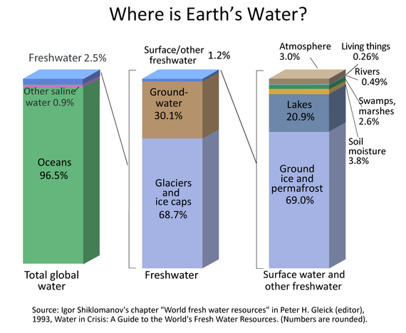
Figure 1
Water Security and Water Scarcity
Water security is defined as "the reliable availability of an acceptable quantity and quality of water for health, livelihoods and production, coupled with an acceptable level of water-related risks.'' Simply put, water security is when there is enough water for everyone and the water supply is not at risk of vanishing. Both quantity and quality of water are consistent indicators of water security: enough quantity to sustain durable livelihood and development, and enough quality to prevent water-related hazards and protect hydro ecosystems.
Today, more than 80% of the world's population live in areas with threats to water security. Thus, water scarcity is the major threat to water security. The growing world population increases the demand for potable water and irrigation water to cultivate crops for food. This provokes a water crisis, when there is not enough water to share among everyone at healthy and acceptable levels. To evaluate whether a given country or region faces water scarcity or water stress, experts use various indicators to illustrate water-population combinations. Thus, for instance, according to the Falkenmark Water Stress Indicator, a country or region is considered having "water stress" when annual water supply per person per year is below 1,700 cubic meters; at under 1,000 cubic meters, the country or the region will be facing “water scarcity.”
Unequal Geographical Distribution of Water
The water security of a country or a region can come under various types of threats, such as biohazards, climate change, natural disasters, political violence and radiation. However, as was mentioned earlier, water scarcity is the most common threat to water security. Water scarcity itself can be physical and economic. According to Figure 2, about one fifth of the world population in regions such as the Middle East, North Africa, India, Central Asia, Northern China, Northern Mexico and Southeastern Australia face severe physical water scarcity.
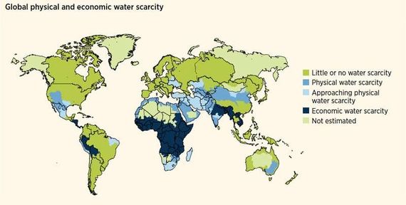
Figure 2
Unequal Consumption of Water
Other regions and countries of the world such as Sub-Saharan Africa with its major rivers—the Congo, Niger and Zambezi—or Eastern Africa with its Great Lakes region and sources of the Nile River, or Peru and Bolivia with their important water sources, as well as Myanmar, Vietnam, Nepal, Bhutan, Bangladesh and many others, suffer from economic water scarcity by not having adequate infrastructure, technology and human capacity to manage their available water resources and provide access to water for their populations. Thus, nearly 25% of the world's population suffers from economic water scarcity.
While an average European’s day includes a cup of water or juice (0.2 L of water), brushing their teeth (1 L), using the toilet (8 L), taking a five-minute shower (100 L), having cereal for breakfast (1 L), drinking tea or coffee (1.5 L for a teapot), washing the dishes (100 L), using the washing machine (100 L), etc., and spending in total about 600 liters of water daily, the poorest African countries’ daily consumption of water per day per person varies between 3-8 liters, equal to just one toilet flush in Europe. In China, the average rate is 100 liters, in Russia up to 400 liters, while the average American consumes about 700-800 liters of water daily per capita. Yet 50 liters would be more than sufficient.
Embodied Water Consumption or Virtual Water
Most of the global freshwater supply, however, is used for agricultural (about 70%) and industrial (about 19%) purposes. Just the production of food takes up 200 million liters of water per second globally. To approximately measure the hidden flow of water in the production of food and other commodities, the notion of virtual water was introduced by British geographer Tony Allan in 2008. Depending on the country, its geographical location, technological advancement, soil quality, weather conditions and other factors, different quantities of water would be needed to grow the same commodity. For example, producing 1 ton of wheat would require 849 cubic meters of water in the U.S., 690 in China, 1,654 in India, 2,375 in Russia, and 3,177 in Mexico, with a world average of 1,334 cubic meters. Furthermore, different commodities have different water intensivity and, sometimes, water scarce countries like Israel restrict exports of their relatively large water-intensive crops or other production overseas.
The few examples listed below help to better understand the water intensivity of different goods:
-
21 tons of water to produce 1 kg of coffee
-
650 L for one slice of toast
-
2,500 L for one hamburger
-
700 L for 1 kg of apples
-
15,000-18,000 L for 1 kg of beef
-
7 L to produce a 1 L plastic bottle
-
200-300 tons of water to produce one car
-
280 L of water for 1 cup of espresso coffee beans
-
30 L for 1 cup of tea leaves
Global Hotspots of Water Disputes
Over the past several decades, many experts, politicians and academics have claimed that the main disputes causing future wars will be over water. In 1979, former Egyptian President Anwar Sadat said that the only matter that could take Egypt to war again is water. Boutros Boutros-Ghali, former Egyptian Foreign Minister and former Secretary-General of the United Nations, predicted that the next war in the Middle East will be fought over water and not politics. In 2001, Kofi Annan also mentioned that fierce competition for fresh water may well become a source of conflict in the future. Former Vice President of the World Bank Ismail Serageldin claimed that the wars of the next century will be over water unless significant changes in governance occurred.
Despite all these claims, the conflicts over water are not a new phenomenon and have historically been one of the major triggers for water competition between and within countries. Although water conflicts are often the substance of larger disputes over territories, natural resources and other strategic interests, they have always been a source of tension between nations. Only within the last 50 years, almost 500 cases of conflicts over water issues have been registered, with about 20 resulting in armed clashes. For perspective, 137 of these conflicts occurred between 2010-2017.
Indeed, the growing population, climate crisis, increase in demand for agricultural, manufacturing and energy production have become strong catalysts for past and future water disputes. For instance, today nearly 60% of global river water is shared between two or more countries. Thus, there are hundreds of ticking timebombs in many parts of the globe that could explode at any moment.
Example of Potential Conflict by Regional Powers: The Grand Ethiopian Renaissance Dam
In 2011, the Ethiopian government started construction on Africa's largest hydroelectric power plant, costing over $4.5 billion, with a reservoir bigger than London. The project raised concerns in Sudan and Egypt. Countries located downstream of the Nile River, especially Egypt, immediately opposed the construction of the dam, stating that it would dramatically decrease the amount of water Egypt receives from the Nile, creating an existential threat to Egyptian national security. However, the conflict has been escalating due to the fact that both countries have water scarcity and stick to diametrically opposite beliefs on water rights. Thus, Egypt refers to its historical rights over the Nile’s water, stating that the construction of the Renaissance Dam would result in approximately an 18.7% decrease in Egypt’s annual Nile watershare.
In 1929, colonial Britain signed an agreement with Egypt granting Cairo the right to veto projects higher up the Nile that would affect its watershare. In 1959, Egypt and Sudan signed the Agreement for the Full Utilization of the Nile Waters, granting 55.5 cubic kilometers to Egypt, 18.5 cubic kilometers to Sudan and 10 cubic kilometers for evaporation. Ethiopia was not consulted, though it is the source of the Blue Nile tributary. In 1970, Egypt finished building the massive High Aswan Dam. Egypt’s 55.5 billion cubic meters/year was adequate for Egypt's 1959 population of 24 million. However, with the current population of over 100 million, Egypt is facing an annual water deficit of around 7 billion cubic meters. According to experts, by 2025 Egypt will possess only about half the per capita water availability that it had in 1990. Moreover, taking into account that the Nile makes up about 90% of Egypt’s freshwater supply and about 85-95% of the total water consumption in Egypt accounts for irrigation, the dam will provoke further desertification of agricultural lands in addition to gradual increases in temperature and evaporation rates that can potentially result in famine.
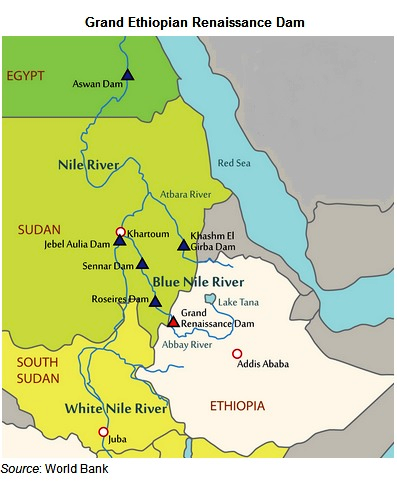
Figure 3
The Ethiopian stance is different: it is more focused on fixing historical injustice. They refer to their rights over the Nile’s water due to its geographic location. Indeed, the Ethiopian Highlands provide 86% of the Nile’s flow, with 70% of that flow coming from the Blue Nile. Meanwhile, Ethiopia is counting on the cheap energy the dam will provide to satisfy the energy and water needs of its own growing population and industries. Roughly 65% of the country is not connected to the power grid. This project will double Ethiopia’s energy output and will make it a net energy exporter.
From time to time, the conflict turns so tense that it goes far beyond diplomatic dialogue. In 2013, at an international panel of experts discussing the Renaissance Dam issue, there were suggestions to destabilize Ethiopia’s internal political situation, supporting anti-governmental players and fueling internal conflicts to distract them from building the dam. Moreover, Egyptian President Mohammad Morsi was also considering the option of the physical destruction of the dam. Thus, Egypt is not only actively working with its international partners to put pressure on and isolate Ethiopia, but as Morsi said, Egypt is open to all options. In response, in 2019, Ethiopian Prime Minister Abiy Ahmed warned that "No force can stop Ethiopia from building a dam. If there is a need to go to war, we could get millions readied." Since then, Ethiopia constantly accuses Egypt of conducting cyberattacks to disrupt its economic activities.
In 2020, the situation was inflamed by the United States. In September, it partially halted economic assistance to the Ethiopian government, arguing that it was due to the lack of progress in Renaissance Dam talks with Egypt and Sudan. In October, President Donald Trump said that the situation got very dangerous as Egypt “is not going to be able to live that way… And I said it loud and clear - they'll blow up that dam. And they have to do something."
Example of a Successful Water Project: The Great Man-Made River Project of Libya
Libya is one of the driest countries in the world. Less than 5% of the country receives 100 mm of rain a year. In 1953, the search for oil in the deserts of southern Libya led to the discovery of not only significant oil reserves, but also vast quantities of freshwater trapped in aquifers under the Libyan Desert. The Nubian Sandstone Aquifer System, today considered the world's largest, is located under the eastern part of the Sahara Desert and spreads far beyond Libya’s borders, also covering Chad, Sudan and Egypt. Its total area is 2 million square kilometers, and it contains an estimated 150,000 cubic kilometers of groundwater. The Libyan discoveries were estimated at about 35,000 cubic kilometers with five large underground lakes, enough to flood all of Germany to a depth of 100 m.
Back then, Libya used to get most of its water supply through desalination plants located in the coastal areas of the country. However, they were very expensive and the volumes were not sufficient to irrigate land for agricultural purposes. Besides, the aquifers of the coastal areas were too contaminated and saline. So, in 1983, an unprecedented engineering project known as the Great Man-Made River Project was initiated to transfer water from desert aquifers to the coastal region of Libya. The project aimed to supply 6.5 million cubic meters of water a day through 4,000 km of pipelines from 1,100 wells via five reservoirs, at an estimated cost of $25 billion. Even at that eye-popping price tag, the cost of this non-renewable water is approximately one tenth of the cost of desalinated water. Through this project, the Libyan government wanted to make Libya water secure for the next century, turning the country into a flourishing garden often referred to as the 8th Wonder of the World. In just six months, agricultural farmland doubled, almost entirely eradicating hunger in the country.
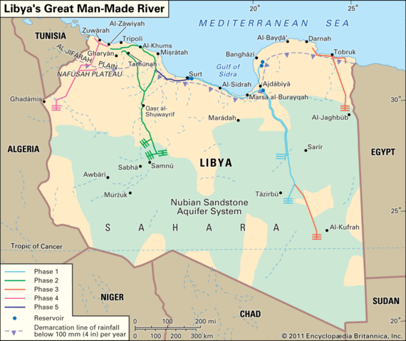
Figure 4
Example of Potential Conflict by Large Powers: The Tibetan Plateau
China has built over 87,000 dams on its rivers, collectively generating about 352 GW of electricity, more than Brazil, Canada and the U.S. combined. For 70 years, China has been building dams on its internal rivers, which has led to the displacement of over 23 million people. However, over the last 40 years, it has increased its hydro power energy capacity by 20 times. Nowadays, after imprisoning its own internal rivers with dams, China has turned its eyes toward building new dams on major international rivers that have their sources in Tibet.
Nearly half of the world population depends on the water tower of Asia: the Tibetan rivers. As China exercises dominant control of these water resources, it is able to dictate its terms to downstream countries using water as a geopolitical tool to impact their foreign policies. The Tibetan Plateau is the source of water for a dozen transnational rivers, including the Yangtze, Yellow, Indus, Ganges, Brahmaputra, Irrawaddy, Salween and Mekong rivers. Most of the freshwater of Pakistan, India, Bangladesh, Nepal, Bhutan, Myanmar, Thailand, Cambodia, Laos and Vietnam takes its origins from the Tibetan glaciers. Therefore, minor changes in water flow could provoke a chain of environmental refugees in the most densely-populated countries of the world. This makes Tibet China’s most important geographic asset.
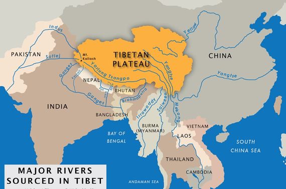
Figure 5
Today, not even 1% of Tibetan hydropower potential is being used. But this is going to change as rapid urbanization and industrialization throughout China increases its needs to build water diversion projects for renewable energy sources. Chinese state-owned companies are lobbying the Chinese government to approve their 28 hydropower projects in Tibet. One of the most debated and tense issues is China’s construction of dams on the Brahmaputra River shared by China, India and Bangladesh. It flows over 2,900 kilometers starting from the Mount of Kailash and empties into the Bay of Bengal in Bangladesh. In 2013, when China approved three new dam projects on the Brahmaputra, India raised major concerns over the flow of water, claiming that these dams would damage the livestock harvest, agricultural yield, freshwater availability and ecology, and affect the lives of nearly 1.3 billion people in downstream India and Bangladesh. However, China not only refused those claims, they gave the green light to build eight more new dams along the river and a few more on its tributaries. With these steps, China is leveraging its control of upstream water access and weaponizing it to contain India’s desire to serve as a regional security provider. There is also another political implication. China wants to transfer the waters from eastern Tibet to Xinjian through a thousand-kilometer long tunnel, to help motivate ethnic Han Chinese migration from the densely-populated coast to the deserted west.
India often refers to the Memorandum of Understanding signed between China and India regarding the water resources of transboundary rivers. However, China rightly argues that, from a legal point of view, it is not a binding document and there is no agreed international body that could ensure its application. Since then, Beijing has strictly opposed any multilateral transboundary water governance agreements with its downstream neighbors. Thus, in 1995, it withdrew from signing an agreement with Mekong river basin countries that would have proclaimed that the Mekong did not belong to any single state. For China, it was a matter of exercising its territorial jurisdiction and that any such proposal is unacceptable for the country. In addition, in 1997, China voted against the UN Convention on the Law of the Non-Navigational Uses of International Watercourses, which tended to create common rules on the governance of transboundary rivers. China’s opposition to commonly managing regional water sources and guaranteeing that downstream countries will get a minimum necessary amount of water also occurred in earlier times when China was a relatively poor country with nearly the same economic output as tiny Hong Kong. At that time, China’s political confidence was less ambitious. If a giant country like India is not able to restrict its appetite, other regional neighbors can only stay silent.
China has constructed 11 mega-dams and intends to build another three new ones along the Mekong River. As a result, the river is shrinking rapidly. For instance, in 2019, the Mekong River’s flow was so low that Cambodia turned off its biggest hydropower plant for lack of water, which caused a few months of electricity blackouts and major economic stagnation in the country. Meanwhile, the low level of the river water allowed seawater to intrude into the delta of the Mekong, destroying Vietnamese and Cambodian farmlands and 90% of Cambodian fishing stocks, which compose about two thirds of the protein of the average Cambodian diet.
The same happened with the Salween River, where China built one mega-dam and plans to build more that can pose significant risks for downstream Myanmar. An unprecedented rate of urbanization and industrialization already threatens water security across South and Southeast Asia. All of these developments are accompanied by climate change, which will prompt the melting of about two thirds of Tibetan glaciers by 2050, and affect the hydro policy and ecosystems of the region differently.
Yet, of all the downstream nations, Bangladesh is in the worst situation. Not only China but also India is building dams on the Ganges River, which has already reduced the water stream to Bangladesh, resulting in an increase in soil salinity, destroying farmlands and forcing millions of Bangladeshis to migrate to India.
Collectively, when China fully implements its hydropower projects along Tibetan rivers, it will create a nightmare for downstream countries, as China will have sufficient leverage in getting geopolitical concessions from its neighbors and adversaries. Meanwhile, China heavily invests and provides cheap electricity to Pakistan, Thailand, Laos and Cambodia to silence the water claims of these countries. This is the way Beijing incrementally subdues its peripheries, having no legal restrictions and obligations, while using Tibet to establish regional hegemony over the surrounding nations.
The Pearls of the Armenian Highlands: Turkey, the Levant and Mesopotamia
The largest part of Turkey’s territory lies within Asia Minor. Compared to the cosmopolitan Marmara region, Asia Minor and the Armenian Highlands to the east are quiet isolated regions. The vast and drought-stricken lands lack navigable rivers, appropriate infrastructure and therefore commercial cost efficiency. Why modern Turkey does not invest to develop this region is a subject of another debate, but the fact is that Asia Minor and the Armenian Plateau have historically been considered the crossroads of various civilizations. Today, besides having geopolitical and geo-economic strategic importance, the region is also crucial for other reasons. Although the region does not possess significant hydrocarbon resources, it has an asset that is far more valuable. The biggest transboundary rivers of the Middle East and South Caucasus, the Euphrates, Tigris, Kura and Araks, as well as several internal rivers such as Aratsani, Chorokh, Halys and Pyramus, trace their origins to the Armenian Highlands, thus giving Turkey an absolute advantage and strategic dominance over its southern and eastern neighbors.
Turkey’s share of the Euphrates River is about 90%, while it benefits from 50% of the Tigris River. These two rivers compose the main source of water for the breadbaskets of Iraq and Syria, making the latter extremely dependent on their northern neightbor’s ambitions and goodwill. As a result, Turkey possesses about 3,100 cubic meters of water per person, 10 times more renewable freshwater resources than its Arab counterparts (300 cubic meters per person in the Arab world).
The first large-scale dams built by Turkey on the Euphrates, Kaban Dam, was finished in 1974, followed by construction of the Karakaya Dam in 1987 that was one of the 21 dams of the Southeastern Anatolian Project, and the Ataturk Dam in 1990, one of the world’s largest dams. The last two projects were specifically troubling for Syria and Iraq. Through the assistance of other Arab countries, they put immense pressure on international financial donors to not provide funds for the construction of the dams. Eventually, Turkey succeeded in finding the necessary funds but was obliged to allow 500 cubic meters of Euphrates water per second on the Turkish-Syrian border.
This situation is especially aggravated by the lack of a formal agreement between Turkey, Syria and Iraq over the management of water. Although Turkey initiated and founded a common intergovernmental commission with Iraq to discuss water issues in 1980, joined by Syria in 1983, the proposals were strictly declined by Syria and Iraq in 1984, after long negotiations. Instead of reaching a mutually-beneficial consensus on water usage, Turkey resorted to escalatory behavior, which almost brought about the initiation of armed conflict. In 1988, President Turgut Ozal even claimed, “We don't tell Arabs what to do with their oil, so we don't accept any suggestion from them about what to do with our water.”
Since the 1960s, Turkey has built a network of nearly 600 dams on both the Euphrates and the Tigris, with another 22 planned for the next decade. Many of these dams are part of the Southeastern Anatolia project that aims to boost economic activity in the region, especially in the central parts of the arable plateau. But experts are convinced that the project is not about producing power and watering crops alone; it is designed to grant Turkey geopolitical leverage.
An aggravating factor is the projected population growth of Iraq (from today’s 39 million to 83 million by 2050 and 163 million by 2100) and Syria (from 17 million to 34 million by 2050), predicting a sharp increase in water consumption. But after construction of the 22 new dams and 19 hydropower plants is complete, Iraq and Syria will find themselves in weaker positions as Turkey will have long-term geopolitical leverage and be able to shape the ecology, climate, demography, economy and thereby the social and political agendas of Damascus and Baghdad.
The consequences are already too obvious. In 2014, because Turkey “blocked” Syria’s water supply, it caused severe droughts and led hundreds of thousands of rural households to abandon their lands. About 3 million people had to flee to urban areas, while a few Syrian hydropower stations had to stop functioning. In 2020, the water level of the Euphrates river in the territory of Syria decreased to such a critical rate that the main water artery of the region practically dried out. This caused an additional humanitarian burden to the war-torn country. Not only did the agriculture and energy sectors come under the threat, but the water itself was no longer suitable for drinking
However, Iraq, the furthest country downstream, was hit the worst. The country is running out of water. It does not control the flows of its rivers, nor does it have the necessary infrastructure to clean the existing water resources. The two biblical rivers are indeed the source of life for Iraq. Around 71% of Iraq’s overall water comes from Turkey, another 10% coming from Syria and Iran. Iran alone has built nearly 600 dams within the last 30 years and dozens of new dams are in the planning stage. Thus, all three countries are holding the two rivers and their tributaries hostage, which today allows for only 25% of the Euphrates’ normal flow to reach Iraq. Along the way, these rivers provide Iraqis with potable and irrigation water, and with electricity. About 80% of Iraq’s water goes to agriculture, which provides a livelihood to more than a third of its 38 million people. By 2035, Iraq will have lost 11 billion cubic meters of water with an annual demand of 71 billion. Some 650 villages already went dry in 2018. All this put massive pressure on Iraq’s infrastructure to clean and distribute the water. However, much of its infrastructure has been destroyed during the three devastating wars Iraq had to go through since the early 1990s.
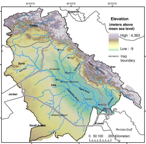
Figure 6
These examples of regional water conflicts are just a drop in the bucket of the huge list of water clashes that took place previously, are taking place now, or can potentially occur in the future. Other examples include the water tensions between Israel and Arabs in the Jordan River conflict, between India and Pakistan over the Indus River, the Central Asian countries located upstream and downstream of the Amu Darya and Syr Darya Rivers, the Guarani Aquifer countries, and many more.
Wealthy North America: Potential Problems between the US, Canada and Mexico
Water conflicts don’t spare rich countries. There exists a conviction that the more developed countries of Europe, North America and Russia will not face serious threats to their water security due to large possessions of water resources, appropriate infrastructure, populations’ better alignment to the existing resources and good relations across borders. However, this idea of relatively healthy water relations between developed nations compared to those in most other parts of the world is being challenged, turning more vulnerable and less predictable.
For instance, even though the U.S. and Canada are strategic allies, enjoy good relations and signed the Boundary Waters Treaty in 1909, the water issue has climbed to the top of the agenda in U.S.-Canada relations. Both Canada and the U.S. possess roughly similar reserves of renewable freshwater resources, but the U.S. has nearly nine times more people than Canada. In 20 years, the U.S. is going to need $384 billion of additional funding to ensure its own population with drinkable water. Climate experts believe that unprecedented climate change will cause significant negative outcomes for the Great Lakes basin, diminishing its water resources.
The same goes for U.S.-Mexico water relations. In 1944, an international pact signed between the U.S. and Mexico defined the sharing and distribution of water resources between the countries. According to the treaty, Mexico receives about four times more water than it provides to the United States. However, Mexico is obliged to deliver water to the States, releasing the dam waters into rivers nourishing the Rio Grande that flows through much of the U.S.-Mexico border. It comprises the vital irrigation sources for southern Texas farmers cultivating vegetables, sugar cane and other crops. But since then, the needs of both societies have changed and the availability of water has exponentially decreased. As a result, in 2020, Mexican farmers and activists from the region of Chihuahua seized the Boquilla Dam on the Conchos River that is a major tributary of the Rio Grande, proceeding to burn cars and governmental buildings. They even held a group of local politicians hostage in order to halt the delivery of the dam’s water, as their own lands were at risk due to severe droughts.
Climate Change and “Water Migration”: A Hypothetical Trajectory
It is obvious that climate change is one of the major factors of increasing water insecurity and stress, and thus an important source of all these conflicts. The Earth’s hydrological cycles are changing, increasing weather unpredictability. Increasing temperatures increases evaporation and precipitation, causing frequent droughts and floods, soil degradation, desertification, sea-level rise and coastal erosion, storms and cyclones, and melting glaciers. This all affects the availability of safe drinkable water and forces people to displace. Many countries are already facing hunger, illness, poverty and economic crises because of the water deficit.
According to experts, by 2050, about 300 million people will become “climate migrants,” the vast majority of which will be caused by water scarcity and an inability to continue socio-economic activities. Will the world economy be able to sustain the forced and climate-induced migration of this many people? There were already up to 50 million “environmental refugees” registered by 2010, and the 10 largest displacements of people in 2016 were climate-related.
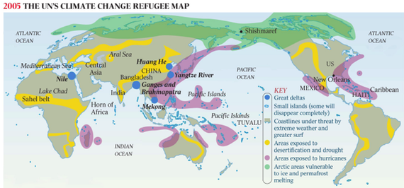
Figure 7
Another 50-70 million people will die from water-related illnesses, such as dysentery, cholera and typhus, in the next decade.
As mentioned previously, rich countries will also bear the consequences and the burden of climate change, considering migration will be toward such countries. Furthermore, the reserves of renewable freshwater resources within rich countries will slowly deplete. For example, since 1850, the volume of European Alpine glaciers has decreased by 60%, and new research shows that more than 90% of the glaciers will disappear by the end of this century, no matter how much emissions are cut. Over 40% of the European Union’s fresh water reserves come from the Alps. The Mediterranean countries, especially Italy, Spain and Greece, will be hit the hardest. In addition, proceeding with this hypothetical assessment, reverse migration from rich countries to less-industrialized countries might also be possible. Because of the freezing Gulf Stream, the population of Northern European countries might migrate massively to the south, to the Mediteranean region, and east toward Russia. To this point, rich countries will be facing unprecedented flows of mass migration that will neither be sustainable nor one that their social systems can absorb.
If the local migrants from affected zones move to the big cities within their own countries, then the regional migrants will be moving toward the North and South, far from the tropics to temperate areas. Thus, the hypothetical projective model in Figure 8 shows that there will be about a dozen major migration routes. For instance, the majority of migrants from the Caribbean, Central America and northern South America will be migrating north to the United States. North Africans will be fleeing north to Europe. Southeast Asians will be heading north to China, Korea, Japan and Russia. Malaysians and Indonesians will be seeking access to Australia, while the populations of Central Asia and the South Caucasus will very likely seek migration toward Russia.
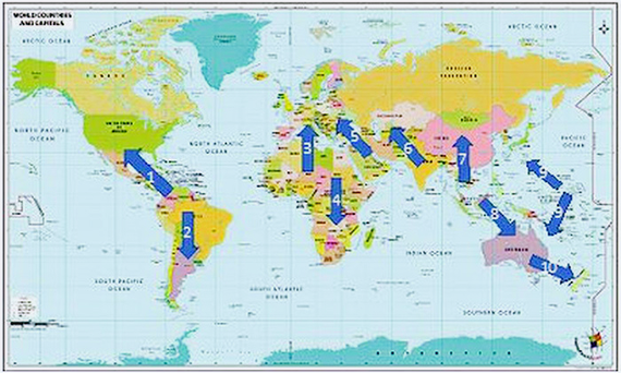
Figure 8
Transnational Corporations and Water as a Geopolitical Weapon
There is no substitute for water. The more scarce it gets, the more access to it becomes a competition. Water is creating a new race among different actors, as was the case for oil and gold in the past. Since water has always been considered a public good, necessary for development, it has not historically been viewed as a commodity. In 2010, the UN recognized access to water and sanitation as a human right. Nevertheless, this pattern has been brought to public debates and largely contested. The proponents of water privatization and commercialization argue that, because of its cheap price, water worldwide is treated as if there will always be enough of it. Therefore, humanity ends up using it in absurdly wasteful ways. To supply water in a safe and sustainable way, water management should be handed over to private companies that have expertise in water politics. These proponents argue that fixing high prices on water would incentivize countries to invest in infrastructure, increase water quality and overcome big water leakages. On the contrary, opponents state that water privatization has historically caused wars, civil disputes and protests, as it makes the services inefficient and very expensive for poor households to access. In addition, high water prices lead to the use of unsanitary water, which causes illness, as the poor cannot afford to pay for safe and secure water.
Good examples include the events in Bolivia in 2000. When the IMF convinced the local government to privatize its water companies, protesters poured into the streets of Cochabamba and forced the American corporate giant Bechtel to leave the country. A similar story happened to the French multinational giant Suez in South America. One of the largest water utility companies in the world had to flee the region due to popular protests in Argentinian cities that were aiming to denounce the 500% water price increase forced by Suez. In South Africa, water privatization led to an outbreak of cholera in 2004.
The examples mentioned above and hundreds of other cases demonstrate that transnational corporations, with the active support of international monetary organizations and donors, have been using the global water crisis as an economic opportunity to pad their profits. Goldman Sachs has predicted that water will be the petroleum of the 21st century. In the next decades, countries will not be rated by their reserves of oil and gas, but of water. Private interests like hedge funds, big corporations, private investors and billionaires buy everything they can related to water. They buy groundwater, lakes and rivers. Water tycoons try to turn water from a universal right to a commodity. Peter Brabeck-Letmathe, the former chairman and CEO of Nestle Group, publicly confessed that he is in favor of giving water a price as we do for other foodstuffs.
On December 8, 2020, the New York Stock Exchange opened its morning trading with a new financial product: traders were selling water futures for the first time, on the same terms as oil and gold. To this end, it is safe to say that Western developed economies are well on their way to commoditizing water.
Water Security in the South Caucasus: Armenian, Georgia and Azerbaijan
Azerbaijan
While Azerbaijan is rich with hydrocarbon reserves, it is very unlucky with its water resources. Out of the three South Caucasian countries that heavily depend on the water of the Kura-Araks basin, Azerbaijan is the worst off, being located downstream of the rivers and facing growing severe water shortages. Around 70% of the country’s water resources form outside of its territory, making it highly dependent on its upstream neighbors. Azerbaijan's overall water resources are estimated to be around 32.3 billion cubic meters. Most of it comes from rivers (30%), lakes (40%) and reservoirs (20%), while the rest comes from groundwaters and springs. However, in drought years, it can decrease to 23.2 billion cubic meters.
According to official data, about half of Azerbaijan's cultivated lands are on the verge of desertification due to erosion, salinization and dehydration; projections suggest that much of it may not be viable for agricultural purposes in the future. Experts claim that, if Azerbaijan does not take the necessary steps to solve its water problem, the desertification process will become irreversible in some parts of the country by 2030. Different estimates show that the current annual water shortage in Azerbaijan is at 4-5 cubic kilometers, but will increase up to 9.5-11.5 cubic kilometers by 2050.
There are about 63 reservoirs in Azerbaijan, the biggest of which, Mingachevir Reservoir, has a carrying capacity of about 15.7 billion cubic meters of water. The second-largest reservoir is the Shamkir Reservoir, which holds around 2.6 billion cubic meters of water. Another 10 new reservoirs, new water pipelines and irrigation canals are planned to be constructed throughout the country by 2022. Nevertheless, water reserves in Azerbaijani reservoirs amount to 11.1 billion cubic meters, while their capacity is 20.5 billion. In other words, half of the capacity is not filled due to lack of water.
The total volume of annual renewable freshwater resources has decreased from 36.6 billion cubic meters in 2000 to 29.4 billion cubic meters in 2017, leaving about 2,999.3 cubic meters per capita per year. Moreover, according to some estimates, the water resources will decrease by another 20% by 2050 due to climate change. The situation is exacerbated by the growing water needs and construction of new dams and reservoirs in the upstream countries. It is estimated that almost 40% of the water of the Kura and 27% of the Araks is no longer reaching the Caspian Sea because of new dams and reservoirs. Azerbaijan also carries the consequences of upstream pollution of the rivers by wastewater, heavy metals, industrial and agricultural chemicals, raw sewage and pharmaceuticals that cause water-related diseases and significant threats to the public health system of the country. All this is accompanied by an intensive loss of biodiversity, deforestation and soil degradation. The flow of the Kura and Araks rivers has reduced so much that saltwater from the Caspian Sea now flows upstream into villages. Azerbaijan also ranks first among CIS countries by percentage of water loss (28%).
On July 24, 2020, for the first time ever, Azerbaijan’s president gathered the government to publicly discuss just one issue: the water economy of the country. “From now on, drinking water and irrigation projects will be on our agenda as the most important issues. The main goal of today's meeting is to eliminate the mistakes and existing shortcomings in this area in the coming years,” Aliyev said.
Georgia
While Finland is called a country of a thousand lakes, Georgia can be considered a country of a thousand springs. Compared to Armenia and Azerbaijan, Georgia possesses plenty of water. It is a water-rich and secure country, with approximately 63 billion cubic meters of total water resources. It has around 26,000 small and large rivers, 850 lakes and 734 glaciers that ensure about 15,500 cubic meters of renewable freshwater resources per capita. The longest river flowing through the territory of Georgia is the Kura (in Georgian Mtkvari - 1364 km). It begins in the mountains of the northern parts of the Armenian Highland, crosses southern and eastern Georgia and flows into the Caspian Sea on the territory of Azerbaijan. Another long river, the Rioni (327 km), originates in the Greater Caucasus Mountains, flows through the Colchis Lowland and into the Black Sea. Another large river of Georgia, the Inguri (213 km), also carries its waters west.
Additionally, there are 43 water reservoirs in the country, 34 for irrigation and nine for power generation. Georgia only gets 18.2% of the Kura-Araks river basin, but it has an oversupply of water. Experts have calculated that water resources make up about one fifth of Georgia's overall natural resources, more than $10 billion. So why drill the land in search of oil and gas if one possesses such wealth? The paradox is that Georgia itself is experiencing a shortage of fresh water. In cities, there are many areas where it is supplied to dwellings on schedule or with pressure restrictions—water is carried to the upper floors from the lower ones in buckets. It is even worse in rural areas: in many villages, there is no running water, and infrastructure is lacking water fields and orchards. While the situation has improved over the last 20 years, there are still big concerns for the country's water policy.
Just as importantly, Georgia also faces the negative effects of climate change, melting glaciers and the sharp reduction of the Alazani and Kura river basins. The continuing change of hydro ecosystems has affected the precipitation rates in the country, provoking droughts especially in the eastern regions of Georgia. Due to the projected decrease in precipitation and increase in temperature by the end of the century, a decrease in runoff is expected to affect the sub-basin Alazani-Ganikh by 25-36%.
It is estimated that Georgia will lose about 11.9% of its water resources by 2030 and 37.8% by 2100 due to the increasing water demand of its residents and industries, agricultural farmland and climate change. Calculations show that, for the last half-century, the total area of glaciers in the Lower Svaneti decreased by as much as 25%, with a corresponding decrease in volume. A study of 113 glaciers in Georgia shows that the average speed of glacier retreat during this period was 8 m/year. Since 1985, the number of glacial lakes has increased by 50%. Risk of flooding due to glacial outburst lakes is large and poses a serious danger to settlements and important infrastructure located in the lower reaches. Thus, in 2014, the melting of the Devdoraki glacier in Georgia caused serious accidents and blocked important infrastructure, along with mudflows and landslides. Meanwhile, the frequency, magnitude and duration of droughts have increased over the past 50 years. The duration of droughts increased from 54 to 72 days.
Meanwhile, the country is building new dams to solve its growing demand for electricity. Today, only 25% of the economically-justified hydro potential is in operation. Georgia can produce an additional 26 TWh per year from hydro resources alone. Therefore, the Georgian government is advocating for the construction of more than 150 large and medium hydro-power plants across the country. Today, Georgia imports electricity from neighbors, especially from Azerbaijan and Russia. The Georgian government uses this argument to convince local communities about the necessity of hydro plant construction projects. However, growing public opposition to those projects due to environmental and social consequences is considerably slowing the implementation of the projects.
Armenia
Armenia is relatively rich in water resources. It is considered a "moderately secured" country with freshwater resources. It possesses over 3,100 cubic meters of water per year per capita, which is quite above the world average of 1,700 cubic meters. There are about 9,480 large and small rivers, with a total length of 23,000 km, as well as more than 100 lakes, some of which dry up in the summer. Collectively, water makes up 4.7% of the country's territory. The surface water area of Armenia is 7.7 billion cubic meters and, according to some experts, Armenians are currently able to use a maximum of 2-2.3 billion. Its rivers are mountainous, characterized by deep canyons and narrow gorges. They belong to the Araks (76.4% of Armenia’s territory) and Kura (23.6%) basins.
The lakes in Armenia are mostly high mountainous and small, except for Lake Sevan. There are also lakes formed in the craters of mountains.
The rivers get their water from underground sources, snow melts and rain. Therefore, their yearly volumes are unpredictable and changing. To overcome the issue related to seasonal fluctuations of river flows, about 80 reservoirs with a total capacity of 1.4 billion cubic meters have been built in Armenia to regulate the flow of mountain rivers, to accumulate meltwater and rainwater for irrigation, to meet energy needs, and to mitigate climate change. Thus, 70 reservoirs are used for irrigation, six are intended for hydropower generation, and only three are dual purpose, i.e. for irrigation and domestic water supply. Before the collapse of the Soviet Union, many canals, 403 pumping stations, and 2,221 deep and artesian wells were built and operated in Armenia.
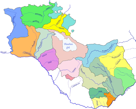
Figure 9
Armenia is also rich with its artesian water basins. Its groundwater reserves are estimated at just over 4 billion cubic meters and are disproportionately distributed. About 70% flows to the Ararat Valley, whose water resources are at a depth of 40-300 m. Groundwater in Armenia is of great importance for water balance. 96% of drinking water comes from groundwater, as it tends to have high quality indicators and is less costly. About 3 billion cubic meters of groundwater is used annually, of which 1.6 billion meters are from springs and 1.4 billion cubic meters from rivers and lakes. It is one of the few countries where most of the community lands are irrigated by groundwater.
However, the largest source of surface water resource is Lake Sevan, which has a volume of about 33 billion cubic meters composing about 80% of Armenia’s water resources. Its fresh water plays an important role for Armenia’s water security landscape.
The 2020 Artsakh War and Water Consequences
Unfortunately, as a result of the 2020 Artsakh War, the Karvachar region of Artsakh came under the control of Azerbaijan. Karvachar does not only have crucial military-strategic significance for the entire region due to being the highest and most invulnerable part of Karabakh, but also plays a key role in the context of water security. Karvachar includes the catchment basins of the two main rivers feeding Lake Sevan, Arpa and Vorotan, along with the Terter and Khachen rivers that provide nearly 85% of the yearly average water supply of Karabakh. Therefore, the largest share of water resources in the former Nagorno-Karabakh Autonomous Oblast (NKAO) originates from outside of its administrative borders. Before the war, Nagorno-Karabakh was in a position to almost entirely secure its environmental security and water resources. After the war, the region as well as the entire Armenian water security architecture came under new security realities of extreme vulnerability and threat.
Today, more than ever, water security should comprise one of the most important components of Armenia's national security. Several important reservoirs fell under Azerbaijani control after the war, including the Mataghis Reservoir, with its 5 million cubic meters of water, and Varanda 1, Varanda 2 and Varanda 3 reservoirs, with 10 million cubic meters of capacity. Overall, 22 out of 24 reservoirs came under Azerbaijani control, although the biggest one in Artsakh, the Sarsang Reservoir, with its 565 million cubic meters of water, was saved from occupation.
Azerbaijan is facing severe water shortage, nearly 90% of its water resources come from outside its borders. The rivers entering Azerbaijan originate mainly in Turkey, passing through Georgia, Iran and Armenia, making the problem of water security more difficult, increasing its dependency on its neighboring countries. Thus, Azerbaijan is planning to build several dams in the newly-occupied territories.
The Turkish Problem
Considering Armenia’s diplomatic relations with Turkey, it is no surprise that relations pertaining to water issues remain quite problematic. Currently, Turkey has about 870 dams or 2.1% of the world’s dams. Since its population will be reaching 100 million by 2030, Turkey wants to achieve energy sufficiency and security by building another 800 dams. Therefore, Turkey has a very aggressive political agenda over water in the region, sitting on the taps of the biggest water resources and defining the water shares for its neighbors. In 2019, Turkey claimed the construction of dams and roads as its top economic development priority. It is estimated that water consumption will reach 100 billion cubic meters in Turkey by 2023.
Armenia’s concerns revolve around Turkey’s self-serving use of the Araks River and its Akhurian tributary. Araks traces its origins to the Armenian Highlands, about 200 kilometers away from the Armenian border with Turkey, and flows over 1,072 kilometers, crossing four countries: Turkey, Armenia, Iran and Azerbaijan. It annually takes about 2.5 billion cubic meters of water to the Caspian Sea. Before entering Armenia, there are four dams on the river, giving the Turkish side control over 54% or 1.4 billion cubic meters of Araks water resources. Turkey is further planning on building new dams, the biggest of which will have 1.3 billion cubic meters of storage capacity, thus holding 70% of Araks water in Turkey. Armenia, in its current state, is already facing a shortage in filling its reservoirs, as the Araks enters Armenia with 60% diminished water compared to previous decades.
Regarding the Akhurian reservoir, it is the biggest in Armenia with a volume of 525 million cubic meters, built in 1980 and agreed to common use with Turkey on a 50/50 basis by the Kars agreements signed between Turkey and the Soviet Union. However, Turkey is breaking those agreements and is not freeing 250 million cubic meters of water toward the dam, by building new dams in upper streams of the river. This directly affects the Shirak, Aragatsotn and Ararat regions of Armenia, leaving many communities with shortages in irrigation water. From 128 villages of the Shirak region, only 35 receive centralized water supply, while 20 villages have no water at all, forcing farmers to rely on underground water or bring it in by other means.
Climate Change, Water Infrastructure and Water Theft
All of the above is aggravated by other factors such as climate change, poor water infrastructure and water theft. Climate change is a major factor affecting countries’ water securities all over the world, and Armenia is not an exception. For instance, if current trends continue, by 2040, the annual average temperature will increase by 1.7-1.8 °C. By 2100, it could increase by 4.5-4.7 °C, which will decrease the influx of water into Lake Sevan by 19%. The consequences, needless to say, will be dire.
Meanwhile, because of poor and old water infrastructure, damaged reservoirs, broken pipelines, and irrigation network malfunction, yearly losses average about 70% of Armenia’s water resources (officially though, water leakages are less than 45%). In 2019, overall consumption was 2.1 billion cubic meters, whereas the remaining 5 billion flowed to the Caspian Sea. About 50% of Armenia's 444,000 hectares of arable land is not used for its intended purpose. Instead, we are witnessing the salinization of lands and scenes of gradual desertification. Today, the de facto yearly average water resources per capita in Armenia is not 3,100 cubic meters as it needs to be, but rather 465 cubic meters, less than in Turkey, Georgia, Azerbaijan and even Iran.
Additionally, hundreds of fish farms mainly use the groundwater of the Ararat Valley, as well as hundreds of small hydropower plants built throughout the country that place additional pressure on Armenia’s hydrosystem. Moreover, many of those farms and plants operate illegally, are constructed with flawed technical and geographical methods, and have served only as a source of income for those associated with the political elite.
Measures to Take
1. First and foremost, the Armenian government should officially declare the water security issue a top priority in its national security strategy and foreign policy agendas.
2. An officially mandated advisory body must be formed, comprised of domestic, diasporan and international experts, with the task of developing strategic policies and long-term solutions.
3. The Government must develop plans for the construction of new water reservoirs. It has been publicized that Armenia is planning to construct 22 new reservoirs, with an overall 139 million cubic meters of additional water capacity that will cost an estimated $220 million over the next 15 years. Urgent attention must be given to the reservoirs of Vedi, Kaps and Yeghvard, with the objective of completing these projects within the next couple of years.
4. Nationalize the country’s water system, from water production, distribution, to water treatment systems. Since water security is an inherent part of national security, the ability of the state to control this exceedingly crucial resource is fundamental to the overall security of the nation. As such, the monetary interests of international corporations must be deprioritized in favor of national security matters that are specific to Armenia’s water security.
5. Form well-equipped and technically-trained special mobile units that will conduct constant and continuous monitoring of Armenia’s strategic water resources, including but not limited to critical water infrastructure, dams, pipelines and treatment plants. These security mechanisms are crucial, considering the high risk of biological and chemical threats to Armenia’s hydrosystem from neighboring Azerbaijan.
6. Develop and implement a nationwide public educational initiative on water consumption. The percentage of wasted water in Armenia is critically high, while irresponsible usage may be mitigated to limit such waste.
7. Armenia must invest and develop transnational water pipelines to partake in the multi-trillion water industry. By investing in water technologies, along with pertinent water pipelines to Iran and the broader Middle East, Armenia may partake in the commoditization of water, but in a responsible way, thus mitigating the pressure that is placed on the country’s hydro-ecosystem.
Also From Our Magazine Issue N9/ Water
The Ups and Downs of Lake Sevan
By Hovhannes Nazaretyan
Lake Sevan is the largest freshwater and alpine lake in the entire South Caucasus. The lake’s artificial outflow which commenced in the early 1930s during the Soviet period resulted in dramatic changes in its water level and continued ecological problems.
Comments
Jaysankar De
9/11/2021, 6:08:11 AMGood article but too much to read for a layman. Unfortunately, the current scenario of water usage in Armenia is even worse. Unplanned and uncontrolled mining activities are contaminating the existing water resources, lack of proper recycling of water, laid back mentality of civilians, both in Yerevan and other parts of the country, in taking water resources and supply for granted, is a big threat. There is need for more stringent actions from the government, while citizens must act wisely. Long live Hayastan 🙏
Shahan Deirmenjian
8/4/2021, 6:56:39 PMA great and timely article on the impacts of water security and scarcity on a global scale. More importantly this article highlights the vulnerabilities of Armenia as a sovereign country surrounded by hostile nations who are in control of the headwaters of major rivers, and have the potential to regulate the water flows traversing through Armenian territory and replenishing our water resources. People living in urban areas, Yerevan being a case in point, take water for granted. Serious strategies must be developed to secure Armenia’s water supply for current as well as for the future stability of our country. Thank you for bringing this timely issue to the forefront.


